Hiking Stage Vojens-Rødekro (31 km)
There are a number of cultural treasures on the stretch of the Hærvej between Vojens and Rødekro. You will cross the first of the Hærvej’s characteristic bridges, Immervad Bro. On your journey, you can also see the Hærulf Stone.
There are a number of cultural treasures on the stretch of the Hærvej between Vojens and Rødekro. You will cross the first of the Hærvej’s characteristic bridges, Immervad Bro. On your journey, you can also see the Hærulf Stone and a little south of Hovslund Stationsby, there is the old Damgård Mill from 1867.
Tørning Mølle
After Vojens, the walking route turns southeast towards Tørning Mølle. In the 14th and 15th centuries, there was conflict between the counts of Holstein and the kings of Denmark, and Tørninghus, South Jutland’s largest castle played a major role. The fortress was on a peninsular in the Haderslev valley, which gave it a strong position to be able to control movement in the region.
Tørning Mill was built in 1908 and is still a functioning electricity producing water mill today (Open 1st May - First Sunday in September). North of the mill is a mill bridge, which was built by German pioneer soldiers just before the outbreak of the First World War. The park contains many rare trees and there are many recreational areas. The bailiff’s house has been converted into a visitors’ centre with landscape exhibition.
After Tørning Mill, the route continues south towards Vedsted, which offers shopping facilities, and past a number of Bronze Age mounds by Vedsted Præstevej, down to Vedsted Lake. There is a track around the lake and in the southeast end, an outdoor swimming pool and recreational area.
Northern Defensive Line
From Ll. Vedbølvej, a track leads up to Pothøj, where on a height on the western side, there is a well preserved observation bunker, part of the Northern Defensive Line. This was a defensive position across the whole of South Jutland, built from 1916-1918, while the area was under German control. Originally, the line consisted of 900 concrete bunkers, of which 31 have been opened to the public.
The Hærvej route continues along the edge of the peat bog conservation area in Abkær Mose and Stengelmose. Near the main road between the marshes, about 0,5 km west of the bicycle route is a bird watching tower, which has an excellent view over the whole area.
Immervad Bro
Afterwards, the journey continues towards the Immervad River, where the Immervad Bridge, has been the main crossing point since 1776. The bridge is built of cut stone, and was presumably originally wooden, although the name Immervad suggests that this was a ford before the bridges were built.
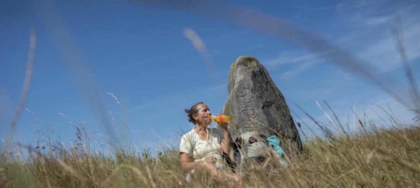
Hærulfstenen
Immediately outside Hovslund Stationsby is a remarkable rune stone at the side of the road.
The inscription is not long - only the name Hærulf or “Hairulfr” as it was written in the 900’s. The stone was moved to Berlin as spoils of war in 1864 and was first returned in 1952, where it now stands in its original place.
In the same location, slightly east of the road is a Bronze Age mound - Strangelshøj, with a 2 m high standing stone close by. A legend says that the stone turns around when it smells bread! There is access to the mound and stone from the rest stop on the road.
Damgård Mølle
A few km after Hovslund Stationsby, you can make a short diversion of around one km west of the Hærvej to Damgaard Mill, which dates from 1867 and has been beautifully restored. Previously used as a buckwheat mill, the working parts are still intact and it is considered to be the best preserved in Denmark. There is access to the mill from the main road under the railway, or via Hovslund Stationsby (Open 1st April - 1st November 10-17)
Vendersvold
Further along, the route passes through Øster Løgum, where a few kilometers south of which is a fortification dating back to the late 200’s, the Vendersvold. The site was originally around 3 km long, of which 500 m can still be seen today. It consists of a moat and ditch the north, which today is an access track. From the Hærvej, there is access from the rest stop on Andholmvej. 1700 years after the fortification was finished, a second defensive system was built on the same site. On the western side, there is a well preserved cannon battery, the Andholmbattery, from the Northern Defensive Line.
Rødekro
The Hærvej goes straight past the old inn in Rødekro and on through the main road in the town. Normally inns are named after the town where they are located, but Rødekro is an exception as the town inherited its name from the inn in 1642. There are good shopping facilities in Rødekro.
Slightly south of Rødekro near Rise Church is a way marker from the time of Christian VII, with the inscription “Weg nach Flensburg und Sleswich”. The romantic period church with distinctive wall studs in the tower, contains well preserved inventory from the Middle Ages.
TO THE NEXT STAGE: RØDEKRO-KLIPLEV